Explore Verde Valley
The Verde Valley in Central Arizona is a picturesque region framed by the Mingus Mountains and Woodchute Mountains, with the winding Verde River flowing through its heart. This lush landscape is home to a cluster of historic towns, vibrant arts communities, wineries, and outdoor recreation spots—making it one of Arizona’s most diverse travel destinations.
Top Things to Do in the Verde Valley
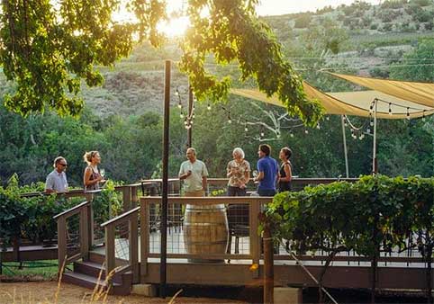
- Wine Tasting & Vineyard Tours – Follow the Verde Valley Wine Trail to sample Arizona’s finest wines in Cottonwood, Jerome, Clarkdale, and Cornville.
- Historic Site Exploration – Step back in time at Jerome State Historic Park, Tuzigoot National Monument, and Fort Verde State Historic Park.
- Scenic Rail Adventures – Ride the Verde Canyon Railroad for breathtaking canyon and river views.
- Outdoor Recreation – Hike in Red Rock State Park, paddle the Verde River, or explore Oak Creek Canyon trails.
- Ghost Tours & Haunted Hotels – Stay overnight at Jerome’s historic and reportedly haunted inns.
- Wildlife Encounters – Visit Out of Africa Wildlife Park in Camp Verde for close-up animal experiences.
- Art & Culture – Browse Sedona and Jerome’s many art galleries, studios, and artisan shops.
Visitors love Old Town Cottonwood for its historic charm, wine-tasting rooms, boutique shops, and top-rated restaurants. Outdoor lovers can explore Dead Horse Ranch State Park, kayak the Verde River, or hike nearby trails.
From Prescott: Take scenic Highway 89A through Jerome (44 miles, ~1 hr 10 min) or Highway 69 to Highway 169 to I-17, then Highway 260 through Camp Verde (54 miles, ~1 hr 15 min).
Perched on Cleopatra Hill above a massive copper deposit, Jerome was once a booming mining town filled with miners, smelter workers, gamblers, bootleggers, and fortune-seekers. Today, it’s a lively hillside community filled with art galleries, wine-tasting rooms, boutique shops, and eateries.
Highlights include the biker-friendly Spirit Room, the Jerome Winery, and famously haunted spots like the Jerome Grand Hotel. History enthusiasts can explore the Jerome State Historic Park, while thrill-seekers can take part in ghost tours.
From Prescott: Take Highway 89A north (35 miles, ~55 minutes).
The oldest settlement in the Verde Valley, Camp Verde was established in 1865 along the Verde River. At 3,100 feet in elevation, this central Arizona hub offers rich history, including Fort Verde State Historic Park, as well as outdoor attractions like Out of Africa Wildlife Park and Montezuma Castle National Monument.
From Prescott: About 58 miles via Highway 169 and I-17 (~1 hr 10 min).
Founded in 1914 as a company town for the Clarkdale Smelter—financed by copper magnate Senator William A. Clark, Clarkdale is now known for its heritage railways and preserved small-town charm. At 3,542 feet, it sits at the upper end of the Verde Valley, surrounded by mesas, buttes, and the scenic Mingus Mountains.
Must-sees include the Verde Canyon Railroad, Tuzigoot National Monument, and the town’s early 20th-century architecture.
From Prescott: Take Highway 89A through Jerome (40 miles, ~1 hr 5 min) or Highway 169 to I-17 to Highway 260 through Camp Verde (58 miles, ~1 hr 25 min).
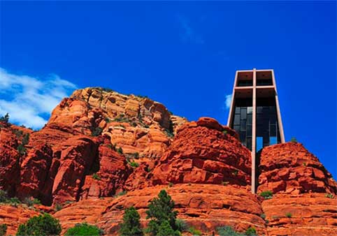
Famous for its red rock landscapes, spiritual vortex sites, and thriving arts scene, Sedona is just 90 minutes from Prescott. The town is surrounded by the Coconino National Forest and offers endless outdoor adventures: hike the 16-mile Oak Creek Canyon, take a rugged Jeep tour, visit Native American ruins, or soar over the landscape on a helicopter ride.
From Prescott: Highway 69 to Highway 169, then I-17 to Highway 179 (67 miles, ~1 hr 25 min).
THINGS TO DO IN VERDE VALLEY
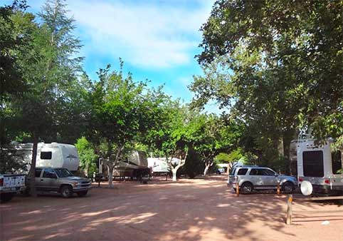
Zane Grey RV Park (55+ park)
Family-Friendly | Pet-Friendly | Laundry | General Store | Propane Refilling Station | Community Restrooms | WiFi
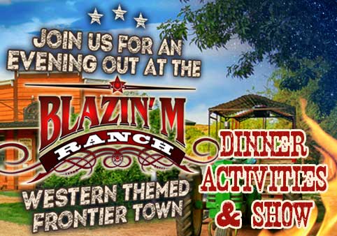
The Blazin’ M Ranch - A Western Themed Frontier Town, Dinner, and A Show
Join us at the Blazin’ M Ranch for an evening of western activities, dinner and an unforgettable show! The Blazin’ M Ranch features an authentic Western Themed Town located in Cottonwood, Arizona. You’ll find fun family activities and the best chicken and ribs in Arizona, along with f … More
Join us at the Blazin’ M Ranch for an evening of western activities, dinner and an unforgettable show! The Blazin’ M Ranch features an authentic Western Themed Town located in Cottonwood, Arizona. You’ll find fun family activities and the best chicken and ribs in Arizona, along with foil-wrapped potato, cowboy beans, our prickly pear coleslaw, flying biscuits and a delicious homemade dessert.
After dinner the Blazin’ M Cowboys entertain ya’ with their award-winning musical talents mixed with cowboy poetry and humor with a 1 hour show from 7:30pm - 8:30pm!
Family-Friendly | Dinner Included | Live Entertainment
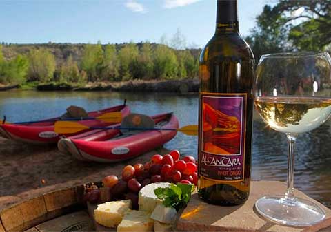
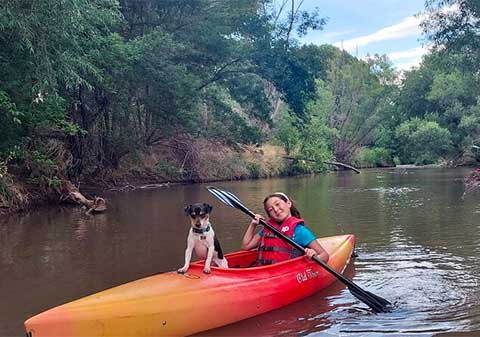
2 Hours Water to Wine Kayak Trip from Cottonwood
The perfect mix of outdoor adventure and relaxation, this tour combines a kayaking excursion with wine tasting in Arizona’s Verde Valley. Paddle down the Verde River in a kayak and stop at a vineyard for a sommelier-led tasting. Feel safe with a guide who can offer paddling and safety t … More
The perfect mix of outdoor adventure and relaxation, this tour combines a kayaking excursion with wine tasting in Arizona’s Verde Valley. Paddle down the Verde River in a kayak and stop at a vineyard for a sommelier-led tasting. Feel safe with a guide who can offer paddling and safety tips, as well as sharing information on the river’s flora and fauna.
Water Activities
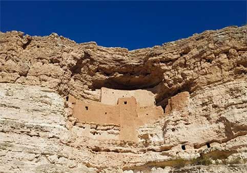
Montezuma Castle, Jerome and Sedona Day Tour From Scottdale or Phoenix
Wine Tour from Sedona to four Verde Valley Vineyards in Luxury Transportation

Private Arizona Wine Tasting Tour, A Divine Vine

Northern Arizona Private Wine Tour south of Sedona - Verde Valley Wineries
Tour Sedona’s Verde Valley wineries on this private wine tour in Sedona. You and your group (max 14) will be driven in a luxury limo- think Mercedes Benz Sprinter or Ford Transit- so no one needs to worry about logistics or driving. You’ll visit three vineyards, where tastings are inclu … More
Tour Sedona’s Verde Valley wineries on this private wine tour in Sedona. You and your group (max 14) will be driven in a luxury limo- think Mercedes Benz Sprinter or Ford Transit- so no one needs to worry about logistics or driving. You’ll visit three vineyards, where tastings are included in the price. Lunch is also included, so you can relax and enjoy this trip with everything taken care of for you.
Sedona with Jerome and Montezuma Castle One-Day Van Tour from Phoenix
Family-Friendly | Beautiful Scenery
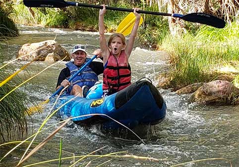
Kayak Tour on the Verde River
Immerse yourself in Arizona’s beautiful scenery—and enjoy a new way to explore—on this family-friendly kayaking tour along the Verde River. Pick between several departure times, grab your safety gear, and set off in a shuttle to the river with just a small group for company. This beginn … More
Immerse yourself in Arizona’s beautiful scenery—and enjoy a new way to explore—on this family-friendly kayaking tour along the Verde River. Pick between several departure times, grab your safety gear, and set off in a shuttle to the river with just a small group for company. This beginner-friendly tour includes a relaxing paddle down a 3.1-mile (5-kilometer) stretch of this river, and the chance to take on gentle mini rapids.
Water Activities | Family-Friendly
Jerome History Walk
PRIVATE Guided River kayaking on the Verde River Cottonwood, AZ (Private Group)
Explore Arizona’s Verde River with a dedicated guide on this private kayak tour. Depart from a designated pickup point in a UTV and enjoy an off-road adventure on the way to the launch point. Sit atop your kayak and enjoy a guided tour through the river, taking in the landscapes along t … More
Explore Arizona’s Verde River with a dedicated guide on this private kayak tour. Depart from a designated pickup point in a UTV and enjoy an off-road adventure on the way to the launch point. Sit atop your kayak and enjoy a guided tour through the river, taking in the landscapes along the way. Enjoy stops at several water holes to swim and cool off before heading back.
Family-Friendly | Pet-Friendly
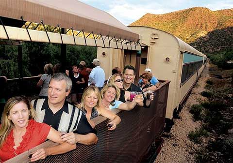
Grape Train Escape: Wine Tasting and Verde Canyon Railroad Adventure
Savor the flavors of the diverse vineyards of Arizona's Verde Valley and beyond. The Verde Canyon Railroad's Grape Train Escape treats passengers to select wines from the Southwest accompanied by specialty cheeses and hors d'oeuvres while winemakers discuss earache wineries terroir and … More
Savor the flavors of the diverse vineyards of Arizona's Verde Valley and beyond. The Verde Canyon Railroad's Grape Train Escape treats passengers to select wines from the Southwest accompanied by specialty cheeses and hors d'oeuvres while winemakers discuss earache wineries terroir and techniques.
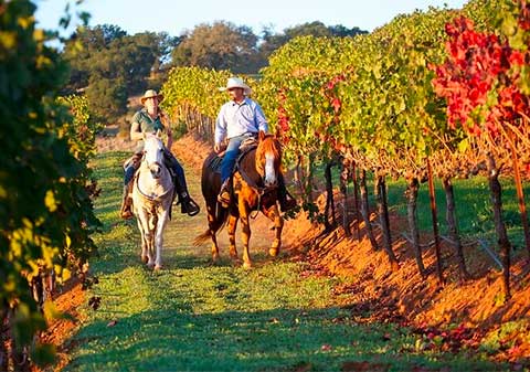
Guided Horseback Tour only 30 mins from Sedona
Go horseback riding in Arizona during this small-group tour in Cottonwood, approximately 30 minutes from Sedona. Meet your guide and set out on a tour through the Alcantara Vineyards. Cross the water where the Verde River and Oak Creek meet, and get up close to see ancient Apache ruins. … More
Go horseback riding in Arizona during this small-group tour in Cottonwood, approximately 30 minutes from Sedona. Meet your guide and set out on a tour through the Alcantara Vineyards. Cross the water where the Verde River and Oak Creek meet, and get up close to see ancient Apache ruins. Admire panoramic mountain views during this scenic excursion. No prior experience is necessary.
Family-Friendly | Professionally Guided
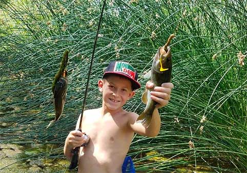
Full-Day Guided Kayak Fishing Down the N. Verde River from Cottonwood
Fishing on Arizona's Verde River offers the opportunity to catch some really awesome fish, but if you don't know the best spots to go to, you may come back empty handed. This Verde River Kayak Fishing Full-Day Experience from Cottonwood takes you down river with a guide and in a kayak, … More
Fishing on Arizona's Verde River offers the opportunity to catch some really awesome fish, but if you don't know the best spots to go to, you may come back empty handed. This Verde River Kayak Fishing Full-Day Experience from Cottonwood takes you down river with a guide and in a kayak, so you not only get to fish in great spots, but you also get closer to the fish, too.
Family-Friendly | Professionally Guided